PHYS/OCSC 2300 - Fall 2026 - Lecture 13
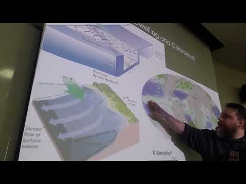 Watch on YouTube →
Overview
The lecture connects wind-driven Ekman transport to vertical ocean circulation, showing how equatorial and coastal upwelling bring nutrient-rich deep water into the sunlit photic zone and support biological productivity. It then surveys Southern Ocean and Atlantic currents, explains how Gulf Stream and Loop Current instabilities form warm- and cold-core rings, and applies geostrophic balance to observed sea-surface-height anomalies.
Key takeaways
- In the Northern Hemisphere, Ekman transport moves 90 degrees to the right of the wind, creating surface divergence and upwelling where the transport points away from a boundary.
- Deep water is nutrient-rich partly because light-dependent biological activity is weak below roughly 200 meters, while marine snow carries nutrients out of the surface layer.
- Westward equatorial trade winds produce northward Ekman transport north of the equator and southward transport south of it, driving persistent equatorial upwelling.
- California coastal upwelling occurs when southward winds drive surface water offshore; reversing the wind can cause onshore transport, downwelling, and reduced surface productivity.
- Gulf Stream ring properties are dynamically linked: cold-core rings south of the current rotate counterclockwise, while warm-core rings north of it rotate clockwise.
- Sea-surface-height highs and lows create pressure gradients that, through geostrophic balance, correspond to clockwise circulation around highs and counterclockwise circulation around lows.
Chapters
- Midterm marks are posted, solutions are expected that afternoon, and students are asked to check that point totals were added correctly.
- Assignment 3 will be posted that afternoon with a full week to complete it.
- Deep-ocean tracers such as nuclear isotopes and CFCs reveal slow circulation: measurements from 1972 and 1981 showed tracer signals moving about 10 degrees south over nine years.
- The North Atlantic subtropical gyre rotates clockwise, with the Gulf Stream, North Atlantic Current, Canary Current, and North Equatorial Current forming its main boundaries.
- Wind friction transfers momentum to the ocean surface, while the Coriolis force deflects currents from the wind direction.
- In the Northern Hemisphere, the surface current flows about 45 degrees to the right of the wind; the velocity weakens and rotates farther right with depth.
- Adding the motion through the Ekman layer gives net Ekman transport 90 degrees to the right of the wind in the Northern Hemisphere.
- At some depth, the current can flow opposite the wind, although that part of the Ekman spiral is weak.
- Upwelling brings colder, nutrient-rich water toward the surface, while downwelling is sinking motion.
- The sunlit photic zone supports phytoplankton, which consume available nutrients; below roughly 200 meters, light is generally insufficient to sustain that activity.
- Nutrients therefore accumulate in deeper water where biological consumption is limited, and marine snow transports biological material and nutrients out of surface layers.
- When upwelling returns deep nutrients to the photic zone, phytoplankton productivity can rise, supporting fisheries and marine food webs.
- At the equator, westward trade winds drive northward Ekman transport north of the equator and southward transport south of it, creating surface divergence and equatorial upwelling.
- Along California, a southward wind drives Ekman transport offshore; water rising from below replaces the water removed from the coast.
- Reversing the coastal wind drives water shoreward, producing convergence, downwelling, and reduced nutrient supply at the surface.
- Satellite ocean-color observations show elevated chlorophyll along the equator and coastlines, including California, consistent with nutrient delivery by upwelling.
- The Antarctic Circumpolar Current, also called the West Wind Drift, flows west to east around Antarctica because no continent blocks its path.
- Strong Southern Hemisphere westerlies drive the ACC, one of the most energetic ocean currents and an important influence on global mixing and carbon cycling.
- Near Antarctica, polar easterlies drive the East Wind Drift in the opposite direction, from east to west.
- The opposing currents create a strong shear zone within the Southern Ocean.
- The North Atlantic subtropical gyre rotates clockwise, with the Gulf Stream on its western edge and the broad, cold Canary Current on its eastern edge.
- The Labrador Current flows south along Labrador and carries icebergs toward Newfoundland.
- The West Greenland Current and East Greenland Current carry water and ice around Greenland; the East Greenland Current can join south-flowing currents near Labrador.
- The Irminger and Norwegian currents are among the additional currents around Greenland, Iceland, and Scandinavia.
- The Gulf Stream is a narrow, powerful western boundary current, roughly 50 to 100 kilometers wide, that flows past Florida and the eastern United States before turning northeast.
- Its turbulent flow develops meanders that can pinch off into rings; the Gulf Stream separates warmer southern waters from cooler northern waters.
- Cold-core rings form south of the current, trap cool water on the warm side, and rotate counterclockwise, or cyclonically.
- Warm-core rings form north of the current, trap warm water on the cold side, and rotate clockwise, or anticyclonically; the Pacific Kuroshio is a comparable western boundary current.
- The Gulf Stream’s upstream flow enters the Gulf of Mexico as the Loop Current, which curves around Cuba before exiting near Florida.
- Loop Current eddies can span hundreds of kilometers and include both warm-core and cold-core features.
- Hurricanes crossing warm-core rings can intensify because warm sea-surface temperatures provide latent heat that supports storm development.
- The Gulf Stream acts as a western boundary layer: friction against the continent helps balance wind-driven gyre spin-up, though the detailed reason for its narrow width is deferred.
- Loop Current observations show sea-surface-height anomalies: red areas are domes about 15 to 30 centimeters above average, while blue areas are lower-than-average bowls.
- Observed currents rotate clockwise around sea-surface highs and counterclockwise around lows, matching anticyclonic and cyclonic circulation in the atmosphere.
- A sea-surface dome creates higher pressure beneath it, while a bowl creates lower pressure; the resulting pressure-gradient force can balance the Coriolis force.
- The next calculation uses a water slab between a northeast high and southwest low to test whether geostrophic balance explains observed currents of roughly 20 centimeters per second.
Transcript excerpt
0:01 Okay, everybody. Welcome back. Um So, um yeah, a few updates. So, the the midterm marks are are posted. Um the solutions should go up this afternoon. Um as always, um please take a look through your midterm to make sure that uh all the all the grade numbers, the points are all added up correctly, uh and things like that. Um occasionally errors do happen. So, if there is any error uh in the grading, uh just let me know um and we'll correct that. Um also, uh the third assignment I've been a little bit behind on posting that, but that'll get posted this afternoon. Uh you'll have a week to do it, so I'm going to adjust the the due dates so you'll have a full week. Um and uh that's about it. Any any any questions about the logistics or anything like
0:48 that? Great. Okay, so today is it's you know um So, it's not Friday the 13th, but it is Friday and lecture 13. Uh so, we're appropriate for uh Halloween season. So, okay. So, so last time so so uh you may Everybody may not have had a chance to review the lecture that was posted. Um it's not going to be too hard to catch up. Things might be a little bit out of order if you haven't seen it, but I'm going to review the major concepts. Um but so, in the in the lecture that was posted, um so, I talked about uh deep deep current measurements. So, so we we first looked at how were we we had this this sort of topic on how were we measuring ocean currents. How do we know uh what the circulation of the ocean is like? And for surface currents, we talked about things like drifters and
This is the start of the transcript. Save this video free for the whole transcript, searchable and time-coded.
Related notes
Summary, takeaways, and chapters were generated by AI from the video's transcript and may contain errors. The video belongs to its creator, JoeFitzgeraldPhysics.