PHYS/OCSC 2300 - Fall 2026 - Lecture 12
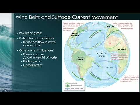 Watch on YouTube →
Overview
The lecture connects ocean circulation to the forces and measurement techniques used to study it, moving from Argo floats and tracers to wind-driven subtropical gyres and Ekman dynamics. It explains how Ekman transport builds sea-surface highs that support geostrophic flow, producing strong western boundary currents such as the Gulf Stream and shaping sea-surface temperature patterns.
Key takeaways
- The five subtropical gyres occupy the North and South Atlantic, North and South Pacific, and Indian Ocean; their rotation reverses across the equator because the Coriolis force changes direction.
- Argo floats provide broad global profiles of temperature, salinity, and pressure, while tritium and chlorofluorocarbon tracer patterns reveal deep circulation that can take years to observe.
- Ekman transport moves water to the right of the wind in the Northern Hemisphere and to the left in the Southern Hemisphere, helping explain how wind patterns build sea-surface highs.
- A sea-surface high drives outward pressure forces, but geostrophic balance with the Coriolis force turns the flow around the high, producing clockwise circulation in the Northern Hemisphere.
- Western intensification makes currents such as the Gulf Stream narrow and powerful, while eastern boundary currents such as the Canary Current are broad and weak.
- The Gulf Stream transports warm water north and the Canary Current transports cool water south, bending North Atlantic sea-surface temperature contours away from a simple latitude-based pattern.
Chapters
- Hurricanes generally move with prevailing winds; in the North Atlantic, the Bermuda High helps steer storms toward North America and Newfoundland.
- Hurricane winds push water toward shore and create storm surge; the low central pressure plays a smaller direct role in raising coastal water levels.
- Surface currents can be measured with GPS-equipped drifters, point-based current meters, and acoustic Doppler current profilers (ADCPs).
- Satellite radar altimetry measures sea-surface height from radar travel time, providing a remote view of ocean highs and lows.
- The Argo program uses thousands of drifting, buoyancy-controlled floats to collect temperature, salinity, and pressure profiles across the global ocean.
- Argo floats surface periodically to transmit data, giving broad global coverage but not continuous observations at every location and time.
- A tracer moves with ocean currents without significantly changing the circulation; injected dye is one example, while salinity is not because it affects density.
- Measurements of nuclear-test tritium and chlorofluorocarbons showed North Atlantic water sinking and moving southward over a nine-year comparison from 1972 to 1981.
- Subtropical gyres form in the North and South Atlantic, North and South Pacific, and Indian Ocean, with continents constraining their basin-scale paths.
- Trade winds drive westward equatorial flow, while mid-latitude westerlies drive eastward flow; the Coriolis effect turns currents at basin boundaries.
- The North Atlantic subtropical gyre rotates clockwise, while its South Atlantic counterpart rotates counterclockwise because Coriolis deflection reverses between hemispheres.
- Subpolar gyres in the North Atlantic and North Pacific rotate opposite to their associated subtropical gyres; the open Southern Ocean does not form a continent-bounded subtropical gyre.
- The North Atlantic subtropical gyre is bounded by the Gulf Stream in the west, the North Atlantic Current in the north, the Canary Current in the east, and the North Equatorial Current in the south.
- The Antarctic Circumpolar Current forms the southern boundary of the Southern Hemisphere subtropical gyres, while the North Pacific and North Atlantic currents bound northern gyres.
- Equatorial trade winds drive westward North and South Equatorial Currents, but a narrow Equatorial Countercurrent flows eastward between them.
- The lecture emphasizes learning the four North Atlantic gyre current names for exams rather than memorizing every current name worldwide.
- Fridtjof Nansen observed Arctic icebergs drifting 20 to 40 degrees to the right of the wind, a puzzle he asked his student Vagn Walfrid Ekman to explain.
- Nansen contributed to oceanographic instrument design, Norwegian independence, and refugee relief; he received the 1922 Nobel Peace Prize for humanitarian work.
- A Niskin bottle, developed as an improvement on Nansen's bottle, is lowered open to a target depth and closed by a descending messenger weight.
- Closing both ends of the bottle at depth preserves an in-situ water sample, such as water from 500 meters, for measurements including salinity and dissolved carbon dioxide.
- Ekman's mathematical model balances wind stress, friction between water layers, and the Coriolis force to explain why surface water does not move directly with the wind.
- In the idealized Northern Hemisphere Ekman spiral, surface flow is about 45 degrees to the right of the wind, while observed iceberg drift is typically 20 to 40 degrees to the right.
- The current weakens and turns progressively with depth, eventually pointing opposite the wind; in the Southern Hemisphere, the turning direction reverses.
- Summing the spiral's flow over depth gives net Ekman transport to the right of the wind in the Northern Hemisphere and to the left in the Southern Hemisphere.
- Satellite radar altimetry maps sea-surface highs and lows; a broad North Atlantic high is linked to wind-driven Ekman transport converging water from the tropics and mid-latitudes.
- Sea-surface height differences of roughly 1 meter above or below average can span hundreds to thousands of kilometers, creating a gradual pressure slope rather than a localized mound.
- Gravity and pressure gradients push water outward from a sea-surface high, while geostrophic balance with the Coriolis force produces clockwise circulation around it in the Northern Hemisphere.
- Friction adds an outward spiral to the otherwise approximately circular geostrophic flow, much like air spiraling outward from an atmospheric high-pressure system.
- The North Atlantic sea-surface high is positioned toward the western side of the basin, leaving a narrow western flow path and a broader eastern return path.
- Western intensification concentrates transport into strong, narrow western boundary currents such as the Gulf Stream; eastern boundary currents such as the Canary Current are broader and weaker.
- Sea-surface temperature contours bend with circulation: the Gulf Stream carries warm water north, while the Canary Current carries cooler water south.
- These temperature patterns reflect both uneven solar heating, with more radiation near the equator, and the redistribution of heat by ocean currents.
Transcript excerpt
0:00 everybody. Uh this is lecture 12 uh replacing the uh in-class lecture that was missed yesterday uh due to scheduling. Okay. So um uh last time we we finished up our discussion uh our our main discussion of atmospheric phenomena uh discussing hurricanes and there were a couple of major topics that we talked about. uh one was hurricane trajectories which is um how do hurricanes actually move? So we know that they uh generally form um in the tropics. So for example um in the tropical North Atlantic although not exactly on the equator because there's no corus effect um and then they drift uh and then eventually you know they might make landfall somewhere and so we discussed what causes them to move in the way that they do. And the conclusion
0:47 was that they basically uh move with the prevailing winds. So whatever way the surrounding wind is blowing they sort of go with the wind like that. And so um this is a schematic um showing how that works. So the little dot here is a hurricane and the idea is that there's a high pressure system here that has a clockwise anti-cyclonic uh circulation around it. Uh and then the hurricane kind of moves with that high pressure. Um and the particular name of the high pressure in this location which is sort of southwest of Newfoundland uh in the North Atlantic is called the Bermuda High. Uh and that particular high pressure system is one um that directs hurricanes up the eastern seabboard um of the of North America and up towards uh Newf Finland where we sometimes get them. Uh we also talked about uh some of the um uh destruction that can be caused by hurricanes and and why they're
1:33 dangerous. Uh and the most important
This is the start of the transcript. Save this video free for the whole transcript, searchable and time-coded.
Related notes
Summary, takeaways, and chapters were generated by AI from the video's transcript and may contain errors. The video belongs to its creator, JoeFitzgeraldPhysics.